Shopping for a canal home on Marco Island and keep seeing “water-direct” in the listing? If you plan to boat, this phrase can make or break your enjoyment. You want a home where getting to the Gulf is easy, not a daily puzzle of low bridges and shallow canals. In this guide, you’ll learn what water-direct really means here, how it compares to indirect access, and the exact checks to confirm a property fits your boat and long‑term plans. Let’s dive in.
Water-direct defined
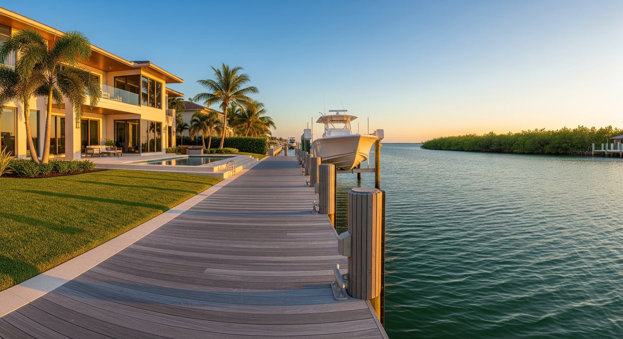
“Water-direct” on Marco Island means your route from dock to open water does not require passing under low fixed bridges or navigating long, shallow, restricted canals. The goal is simple, practical access to the Gulf via the island’s channels or the Marco River.
It is a helpful signal in listings, but it is not a legal or standardized term. Actual navigability depends on your boat’s draft and air draft, channel depths at low tide, and local conditions. Treat “water-direct” as a starting point, then verify the details that matter to your vessel.
Water-direct vs. indirect
Water direct homes usually offer a shorter, more straightforward path to open water. Water indirect homes often involve fixed bridges, longer meanders, or shallower stretches before you reach the Gulf. Here are the key factors that decide what will work for you.
Depth and boat draft
Draft is the distance from the waterline to the bottom of your boat’s keel. It is the main limit in shallow canals. Many canals can shoal over time, which means a route that works at high tide might not be passable at low tide for deeper boats.
- Flats boats and skiffs: about 6 inches to 2 feet of draft. These are well suited to many shallow canals.
- Bay boats and small cruisers: about 1.5 to 3.5 feet of draft. These need modest depth and consistent channels.
- Larger cruisers and trawlers: about 3.5 to 6+ feet of draft. These typically need maintained, deeper routes and true water-direct access.
Action step: Verify channel depth at mean low water. Ask for recent soundings or a small-craft bathymetric survey. Note any history of shoaling or dredging.
Bridges and air draft
Air draft is the height from the waterline to the highest fixed point on your boat. Fixed bridges with low clearance can block tall powerboats and most sailboats, even if depth is fine.
Action step: Identify every bridge on your route and confirm the lowest clearance. If there is a drawbridge, note schedule and operating rules. For sailboats, compare mast height to the lowest fixed clearance on the route.
Tides and seasonal change
Southwest Florida’s tidal range is moderate, but low tides can still reduce usable depth in shallow canals. Wind, storm surge, and seasonal sediment movement can shift conditions.
Action step: Check tide tables for predicted low-water levels when you plan to use the route. Ask local marinas about any seasonal shoaling patterns.
Route length and restrictions
Direct routes tend to be shorter and straighter. Indirect routes may wind through narrow canals or protected mangrove areas with slow or no-wake zones. That can add time and limit when and how fast you can travel.
Action step: Trace the full route to the Gulf and note any speed restrictions or protected zones that affect travel time.
Regulations and environment
Dock work, dredging, and seawall improvements require permits from state and local agencies, and sometimes federal authorities. Mangrove and seagrass protections, manatee zones, and other rules can limit where you can navigate or alter the shoreline.
Action step: Review permitting history for the property. Confirm what is allowed for any future dock, lift, or dredging plans.
Does it fit your boat?
Use these quick rules of thumb to gauge fit, then verify on site.
- Flats and skiffs (about 0.5 to 2 ft draft): Forgiving in shallow canals and often fine on indirect routes. Air draft rarely an issue.
- Bay boats and small cuddy cabins (about 1.5 to 3 ft): Usually good on water-direct canals. Indirect canals may work if they are maintained and not too shallow.
- Larger express cruisers and trawlers (about 3 to 5+ ft): Often need true water-direct access and deeper channels. Depth at low tide is critical.
- Sailboats: Depth might be fine, but fixed bridge clearance is often the deciding factor. Confirm no low fixed bridges on the route.
- Yachts: Deeper draft and taller profiles typically require deepwater docks, well-maintained channels, and no bridge restrictions.
Tip: If you think you might upsize later, evaluate the property for the largest boat you could reasonably own, not just the one you have today.
How to verify a listing
A “water-direct” label should start a conversation, not end it. Here is a practical due-diligence path.
Map the route
Request a map from the dock to the Gulf. Mark bridges, narrow passages, mangrove or no-motor zones, and any protected areas. A clear route map helps you compare properties.
Confirm depths at low water
Ask for recent depth soundings or commission a small-craft bathymetric survey. Cross-check with nautical charts, but remember charts are generalized and may not show recent shoaling.
Check bridge clearances
List each bridge on the route and note the lowest fixed clearance. For drawbridges, record opening schedules and any operating limits.
Inspect dock and seawall
Confirm ownership and whether the dock is private or community. Review mooring rights, setbacks, easements, and lift capacity. The seawall’s condition can affect both safety and insurance.
Review permits and future plans
Verify permits for existing dock, lift, and seawall. Ask what will be required for future changes, including any need for submerged-lands authorization or federal review if applicable.
Understand HOA rules
If the home is in an association, check rules on boat type, length, overnight docking, and slip usage. Some communities have specific standards.
Ask about dredging
Who maintains the canal and when was it last dredged? Is future dredging planned or even possible under current environmental rules?
Consider flood and insurance
Check the FEMA flood zone and request an elevation certificate if available. Understand implications for flood and wind insurance, and note how seawall condition can affect coverage.
Talk to local operators
Marinas, harbormasters, and seasoned local boaters can share up-to-date insights on channel depths and tricky spots that do not show up on a map.
Sea trial if unsure
If it is a major purchase, consider piloting the intended boat, or a similar one, along the route at low tide. Nothing beats a real-world test.
Permits, insurance, long-term view
- Permitting: Dock, lift, seawall, and dredging work usually involve local building approvals, state coastal and submerged-lands permissions, and sometimes federal permits.
- Environmental protections: Mangroves, seagrass, and wildlife zones can limit dredging or alter how you navigate. Expect slow or no-wake segments in sensitive areas.
- Resilience: Sea level rise and storm surge can change how you use your dock over time. Seawall height and condition and dock elevations influence long-term usability and insurance.
- Insurance: Flood zone, elevation, and the state of your seawall and dock can affect premiums. Boat insurers may require certain dock or lift standards.
Buyer cheat sheet
Use this short list to compare canal homes side by side.
- Map the exact route to the Gulf and list any bridges or restrictions.
- Get recent depth soundings at mean low water.
- Confirm the lowest bridge clearance against your boat’s air draft.
- Inspect the dock and seawall, including ownership and maintenance.
- Review current permits and what will be required for future work.
- Check HOA rules for boat type, length, and overnight policies.
- Confirm FEMA flood zone and review insurance implications.
- Ask who maintains the canal and when it was last dredged.
- Do a trial run at low tide if possible.
- Consult a local marine professional before closing if needed.
Next steps on Marco Island
If you want your boat to be part of daily life, the right canal matters as much as the right kitchen. We help you connect the dots between your vessel, your route, and your long-term plans, including coordinating local depth checks, bridge clearance confirmations, and marina input. Ready to compare water-direct options and verify the details that fit your lifestyle? Reach out to the Marco Island Life portal and the Heuermann-Skirkanich Team for personalized guidance.
FAQs
What does “water-direct” mean on Marco Island?
- It indicates a route from dock to open water with no low fixed bridges or long shallow detours, but you should still verify depths, bridge clearances, and tides for your specific boat.
How do bridges impact canal access for sailboats?
- Fixed low bridges can block masted boats entirely, so you must confirm the lowest clearance on the route and compare it to your mast height and any antennas or arches.
How can I check canal depth near a home?
- Ask for recent depth soundings at mean low water or commission a small-craft bathymetric survey, then compare findings with local knowledge from marinas.
What permits are needed for a new boat lift?
- You typically need local building approvals and may require state or federal authorizations depending on location; review the property’s permitting history before planning upgrades.
Is paying more for water-direct worth it?
- If you have a deeper-draft or taller boat, water-direct access can save time and expand where and when you can travel, but the value depends on your vessel and how often you plan to use it.